Tuesday,
February 11, 2025
Year : 2, Issue: 24
by John Bacon and Doyle Rice
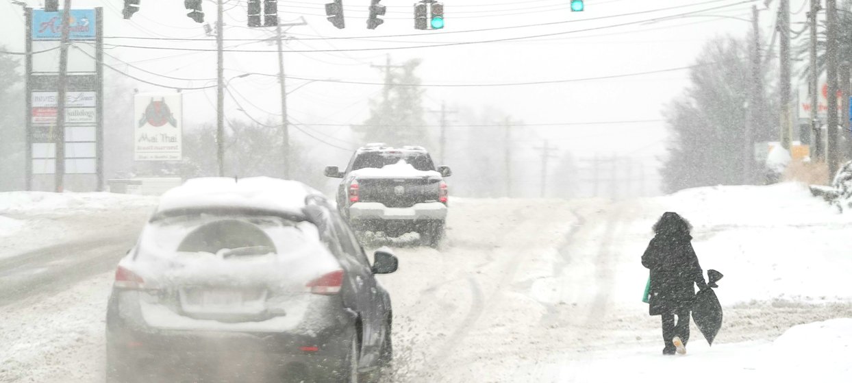
Two powerful weather systems were careening across the nation Tuesday, threatening to dump up to a foot of snow in some areas while snarling traffic, clogging roadways, shuttering schools and shutting down government offices.
The storms were racing across more than a dozen states from Missouri to Virginia and 200,000 square miles, AccuWeather said. In some locations, snowfall rates of 1-2 inches per hour could make it impossible for crews to keep roads open.
The first of two storms within 24 hours was targeting a stretch from Kentucky to New Jersey and Delaware with was expected to reach 3-6 inches of accumulation, AccuWeather said. But snow totals could hit 6-12 inches in Washington, D.C., parts of northern Virginia including this D.C. suburb, and eastern West Virginia, according to AccuWeather. Snow began to fall midafternoon Tuesday in the Washington, D.C., area, forcing the federal government to shut down for the day.
Weather Trader meteorologist Ryan Maue wrote on X that the snow combined with ice and freezing rain expected later would make “quite a mess.”
Nation’s capital girds for storm
Many school districts around Washington, D.C., closed early Tuesday in anticipation of the snow, and more than 170 flights into and out of Ronald Reagan Washington National Airport had been canceled even before the snow arrived.
Mayor Muriel Bowser declared a snow emergency for the city effective Tuesday at 6:30 p.m. Bowser deployed the city’s Snow Team, preparing 136 heavy plows including six- and 10-wheel dump trucks to treat highways, streets, bridges, ramps and other elevated structures, and 82 light plows on pickups to treat smaller streets.
Bowser also said a cold weather emergency may be declared, which would provide additional services to protect residents from “life-threatening illness and injuries associated with severe cold weather.” Outreach efforts would help vulnerable residents access shelters and other resources, she said.
“All employees must depart no later than 2:00 PM, with option for unscheduled leave or unscheduled telework,” the Office of Personnel Management announced on its website.
Severe storms possible in South
Isolated strong to severe thunderstorms are possible from south Texas into parts of Mississippi and Alabama through Tuesday night, the Storm Prediction Center said, citing “the potential for isolated wind damage and perhaps a tornado.” The chances for severe thunderstorms are greater on Wednesday, mainly across eastern Louisiana, central Mississippi and western Alabama.
The risk of severe weather, including tornadoes in the Southern states, may be even greater with a storm forecast to travel across the eastern half of the nation this weekend, AccuWeather said.
Wind chill could reach 50 degrees below zero
Some of the coldest air of the winter was spreading across the northern Plains on Tuesday. People in Montana, the Dakotas and Minnesota were enduring temperatures Tuesday morning in the minus 20s and minus 30s, Maue said. The National Weather Service in North Dakota warned that “life-threatening wind chills as low as 50 below zero could cause frostbite on exposed skin in as little as 10 minutes. If you must go outside, dress in layers including a hat, face mask and gloves. Keep pets indoors as much as possible.”
After a slight moderation in temperatures for Thursday, very cold temperatures and wind chills will return Valentine`s Day through the weekend, the weather service said. The cold air will then make its way across the country over the next week or so.
Second storm to roll from Chicago to DC
That first storm fueled only flurries in Kansas City, Missouri, but a second winter storm was expected to slam the region Tuesday night through Wednesday night. Snowfall accumulations of 4-8 inches were forecast for some areas, and a glaze of ice was possible in others, the National Weather Service office in Kansas City posted on social media.
The weather service in Chicago warned of accumulating Wednesday that will “significantly impact the Wednesday PM commute.”
The second storm will slide across the East, too, bringing snow, sleet and rain to Washington just hours after the first snowstorm. Before both storms are done, some areas around the nation’s capital could see 6-11 inches of snow and up to a half-inch of ice, the National Weather Service said.
Flood watch in California as atmospheric river approaches
Southern California was on high alert for mudslides and landslides, and rain was in the forecast for the area starting Tuesday and lasting through Thursday. The National Weather Service said up to 3 inches of rain could fall in the Los Angeles area, where deadly wildfires last month destroyed thousands of homes and businesses and scorched thousands of acres of land.
“Flash flooding and debris flows caused by excessive rainfall are possible … in and near numerous burn scars in much of Los Angeles and Ventura Counties,” the National Weather Service warned. The heaviest rain was forecast for Thursday; the greatest risk was near the sites of the Eaton, Palisades and Bridge fires, the weather service said in an advisory.